The Rectory, Palace Street, Canterbury.
A unique oddity within Canterbury, and one that is often overlooked when you find yourself walking along Palace Street also known as the King’s Mile in Canterbury.

One of the most striking landmarks along Palace Street is of course the former church of St Alphege, named after the 11th century Archbishop who’s notability came from the extensive reforms made to monastic practice and liturgical dissemination to better align English practices of Christianity to that of the continent, after the Norman occupation. However Archbishop Lanfranc’s career was cut short after he was held at ransom by the Danes before meeting his untimely demise.
St Alphege Church
The original church was built in 1070 by archbishop Lanfranc however this is not the original construction as it has been rebuilt several times over the years. The most recent addition dates to the 15th Century.

The small church was located just outside of the precinct boundary and provided a communal space for local residents to worship outside of the standard practice that is synonymous with the Cathedral.
This church remained in use until 1982 when it became home to the Canterbury Environment Centre. However to date it is currently owned by the King’s School with a plaque demarcating its use as a drama rehearsal space.
However all this preamble is a nice segue into this post, however it has very little to do with the actual property of 8 Palace Street. Also known as The Rectory.

8 Palace Street
8 Palace Street is a typical example of Norman Architecture being superseded by Jacobean renovation and extension.
The building we see today was renovated in 1665, however the original construction dates from approximately 1250.
The façade of this building is worthy of its own investigation, however I want to draw your attention away from the beautiful engravings on the oak bargeboards, gargoyle brackets and delicate lead lined windows.
Instead I want to focus on the eastern façade.

We can see a stark contrast in materiality.
The first thing that you will probably notice about this façade is the heavy use of mathematical tiles that cover the entire façade. The second thing that you’ll probably notice are the miniscule and infrequent placement of windows on this façade.
So what happened?
The ’vacant space’ between the property and the church acted as a walled garden for number 8. This garden could be accessed from Palace Street via the existing Norman Wall, through the archway.
However once the property fell into the ownership of the church, a desire to expand the existing provision of the rectory called for an expansion to the existing floor plan.

In 1665, major extensions at number 8 were made to accommodate the expansion of the rectory for the church of St Alphege. With a proposal for an entirely new structure enclosing the gap between the church and the existing property.

The new extension initially served as an independent dwelling house, with the primary entrance to the property being through the Norman Archway. However, floor plans show that the provision of a chimney flue and stairwell sought greater integration between the two units than initially constructed.
On this eastern façade a central chimney stack was proposed to heat the annex to the existing property at number 8, in addition to a stairwell to the north of the property sought to provide access to the upper floors. However this later proposed issues with circulation, accessibility to the smaller herbarium/ garden and the demolition of a gothic window/ archway to the rear of the property.
Sadly the rectory was demolished in the 1880s and subsequently the eastern façade of number 8 was returned to its former appearance. Well as best as it could be.
The new stairwell and accessway to the rear garden saw the removal of the gothic archway to the rear of the property and a new external doorway was installed to provide garden access. So as to not have the primary entrance being separated from the property.

Number 8 went on to become a commercial property with a temporary shop front being installed on the ground floor.
The property saw many iterations over its lifetime, ranging from a newsagent/ tobacconist and until its recent closure, it functioned as an antiques shop.
The vacant space left behind by the rectory’s demolition returned back to a private garden for the property at number 8. The Victorian brick wall was plastered overdue to structural concerns with the meeting point of the existing Norman flint wall that abutted the Church.

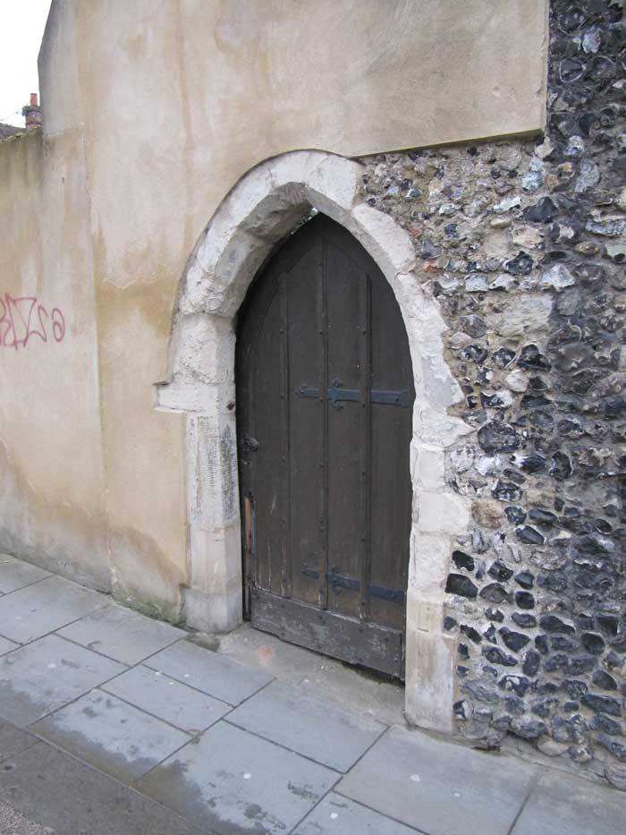
The only evidence of this fascinating snippet from history is seen within the Norman Archway that faces onto Palace Street. This small detail is easily overlooked but leaves an eternal reminder of what once was and what may never be again.
Sources
Bateman, A. (2001), Palace Street Historical Guide, Canterbury Environment Centre: Canterbury.
Bax, S. (1999), Canterbury Buildings: 8 Palace Street, [online] At: Canterbury Buildings- 8 Palace Street.
Canterbury Historical and Archaeological Society. (2015), 8 Palace Street Canterbury History, [online] At: http://www.canterbury-archaeology.org.uk/8palace/4590809439.
Machado, T. (2007), Historic Canterbury: no. 8 Palace Street. [online] At:machadoink.com (Accessed 27/03.2023).
Parkin, E, W. (1969), The old rectory of St. Alphege, Kent Archaeological Society: Canterbury.
List of Illustrations
Kirtley, J. (2021) 8 Palace Street, Photograph
Lyle. (2008) Corner view of St Alphege Church, [online] At:St Alphege’s Church – Canterbury Historical and Archaeological Society (canterbury-archaeology.org.uk), (Accessed 27/03/2023).
Machado, T. (2014) 8 Palace Street Today, Photograph, [online] At: http://machadoink.com/Palace%20Street.htm, (Accessed 27/03/2023).
Google. (2022), Street view of the East Elevation of no.8 Palace Street, [online] At:8 Palace St – Google Maps, (Accessed 27/03/2023).
Canterbury History and Archaeological Society. (2015),Engraving of Rectory Elevation, [online] At: canterbury-archaeology.org.uk, (Accessed 27/03/2023).
Machado, T. (2014) 8 Palace Street c.1900, Photograph, [online] At: http://machadoink.com/Palace%20Street.htm, (Accessed 27/03/2023)Google. (2022), Street view of the Norman Arch, [online] At:8 Palace St – Google Maps, (Accessed 27/03/2023).